Sunday, September 19, 2010

Adventures in South Africa – Around Cape Town: Cape Point, St. James and Boulders Penguin Colony

South Africa’s Western Cape is very different than the rest of the African continent.  People from Europe and the United States will find it a lot more similar to their own home countries.  Cape Town especially is a great place to end a long excursion through the African wilds and transition back to one’s usual life.

Cape Point is part of the south-western section of the Table Mountain National Park.  It offers spectacular scenery and breathtaking views of the fynbos (the natural scrubland that occurs only in a small area of the Western Cape of South Africa).  The area offers unique flora and fauna not seen anywhere else.  It is a short drive out of Cape Town and well worth your time to see.

St James is a coastal suburb of Cape Town.  It is a retreat where visitors walk along the ocean’s edge and swim in tidal pools. The beach is not all that big but the small size adds to its charm.  St. James also has one of the most photographed features in the area; its trademark brightly colored bathing houses that line the waterfront.

The Boulders penguin colony is the home of a growing colony of the vulnerable African Penguin (AKA: jackass penguins due to their braying calls).  Wooden walkways allow visitors to view the penguins close up in their natural habitat without disturbing the many nests along the beachfront.

We visited all three areas in the same day, but it would have been nice to spend a weekend enjoying the beaches and restaurants along the way.  This time we were on a tight schedule.  Our overland excursion was coming to an end, and there was a lot more of South Africa to see on our own - Onwards to our next ‘Adventure in Traveling’.

Sunday, September 12, 2010

Adventures in South Africa - Augrabies Falls National Park and the Dassie Trail

 About 120 kilometers west of Upington, in a landscape full of sand and scrub, the Orange River cuts through solid rock in a dramatic sequence of rapids and cascades.  Its rushing waters breach the main gorge and become Augrabies falls, dropping 56 meters before continuing in a tumble of cataracts, to a turbulent rock-enclosed pool.  The area surrounding the waterfall has been designated a National Park and includes 15,400 hectares of unique riverine and scrub landscapes.

The area is popular with nature lovers and photographers, and although it is not a ‘Big Five’ park, Springbok, Klipspringer, Eland, Giraffe and Black Rhino can be seen along with many bird species, lizards, the Cape clawless otter and the rock dassie (Hyrax).  There are several good hiking trails in the park, the most popular being the three-day/39.5 kilometer Klipspringer Trail, but we had only a day to enjoy the park, so opted for the much shorter (5 kilometer - but still very interesting and varied) Dassie Trail.

The self-guided Dassie Hiking Trail leads you on a circular route starting and ending at the Rest Camp.  The trail follows the gorge to Arrow Point, and then heads out into the veld, past the Potholes and Moon rock(the rounded top of a massive bolder), before returning.  Along the rock faces dassies and red-tailed lizards are common.  While overhead we saw a Verreaux’s (Black) Eagle and several European Bee-eaters.

The trail is worth walking just to experience the varied landscapes, but it is also a great place to experience some of Africa’s smaller creatures.  The Augrabies Falls National Park is a wonderful place to have a milder kind of Adventure in Traveling.

Thursday, August 26, 2010

Adventures in South Africa - The Kgalagardi Transfrontier Park

The Kgalagardi Transfrontier Park straddles the border between South Africa and Botswana and comprises two adjoining national parks: Kalahari Gemsbok National Park in South Africa and Gemsbok National Park in Botswana. Its total area is 38,000 square kilometers (15,000 sq miles). Approximately three-quarters of the park lie in Botswana and one-quarter in South Africa.  The terrain consists of red sand dunes, sparse vegetation with occasional trees, and the dry riverbeds of the Nossob and Auob rivers. The rivers flow only about once per century, but a flow of water underground provides life for grass and camelthorn trees growing in the riverbeds.

The weather in the Kalahari can be extreme.  Midsummer temperatures are often in excess of 40 °C (104 °F) and winter nights can be quite cold with temperatures below freezing.  Regardless of the hardships, the park has abundant wildlife. It is the home of large predators such as the black-manned Kalahari lion, cheetah, leopard, and hyena. Migrating herds of large herbivores such as wildebeest, springbok, eland, and hartebeest also live in the park.

There are three well-equipped camps on the South African side of the park, namely Twee Rivieren, Nossob and Mata Mata.  From Upington, Twee Rivieren is 260 kilometers north and it the closest.  We spent one night there before going as far north as Nossob.  We returned to Twee Rivieren for one more night before leaving the park.  All camps have a small shop with food, ice and drinks as well as fuel pumps.  Hundreds of ground squirrel dens also litter the camping areas.  Their antics are truly fun to watch while resting around the campfire, but watch where you place your feet.

The arid landscape of the Kalahari reminded me of Etosha National Park in Namibia, but the dry riverbeds gave it more contour.  The grass can be quite high, so being in a truck, high off the ground, gave us a game spotting advantage.  Also note, many of the roads through the Transfrontier require a 4x4 and should only be attempted in a caravan of at least three vehicles.  That said the game viewing was tremendous.  Our first night, we went on a night drive with a park ranger.  Among many other animals, we saw an Egyptian cobra, bat-eared foxes, springhares, many night birds and countless species of antelope.  Over the next few days, we had the luck to see leopard, cheetah, jackal, hyena, giraffe, zebra, wildebeest, hartebeest, eland, gemsbok, springbok, and so much more.  However, the highlight for me was when we were leaving the park and ran across a pride of lion feeding at a gemsbok kill.


Sunday, August 15, 2010

Traveling through Southern Africa (Part15) – The Fish River Canyon

The Fish River Canyon is one of the great natural wonders of Africa. It is one of the largest canyons in the world ranking with the Colca Canyon in Peru and the Grand Canyon in the U.S.A. The Fish River has its source east of the Naukluft Mountains and from there it flows down into the great Orange River. The river has cut a canyon into the escarpment more than 150 kilometers long, up to 27 km wide, and in places, almost 550 meters deep. The lookout points from the top give breathtaking views, especially at sunset when orange light bathes the canyon walls. 

The Fish River Hiking Trail starts at Hobas and ends 85 kilometers (53 miles) further south at the hot springs resort village of Ai Ais. No facilities are available and hikers must make their own camps for the entire trip, which usually takes about 5 days to complete.  Due to high summer temperatures, which frequently exceed 45°C, the trail is only open in winter. The season runs from mid-April to mid-September (wintertime in the Southern Hemisphere). A medical certificate is required to attempt the hike and groups must consist of at least three people.

We would have loved to walk the entire trail, and hope to do so someday, but this time the schedule only allowed us the afternoon to descend to the Orange River and back.  It was a walk that took 45 minutes down and about twice as long to climb back up.  The trails are in good
condition, but hard, very rocky and at times confusing.  We learned just to continue downhill for a short while and the path would reappear.  It was a walk into another realm. The trail is full of interesting rock formations, plant life and the occasional reptile, well worth the effort to experience.

Upon returning to the lookout, the setting sun rewarded us with some breathtaking views of the canyon.  I am always amused by the fact that the more rugged the landscape the more beautiful it appears from afar.

Sunday, August 8, 2010

Traveling through Southern Africa (Part14) – luderitz, Kolmanskop and Halifax Island


Luderitz is a German colonial town on the Namib Desert coast, seemingly untouched by the 20th century.  It began life in the late 1800s as a harbor and trading post, but the bay’s shallow water and rocky bottom, make it unusable for modern ships.  Today Luderitz is a tourist town with shops and restaurants.  Its main draw for visitors are wildlife cruises and the nearby ghost town of Kolmanskop.

Just off the coast is a marine wildlife sanctuary that can be visited by boat.  There, you have an opportunity to see African penguins, sea lions, white-sided dolphins, flamingos and many other marine bird species.

The day after arriving in Luderitz, we walked to the harbor from our campsite to board the schooner, Sedina, for a morning cruise.  We sailed into luderitz bay,  past the lighthouse at Diaz Point and on to Halifax Island.  Several dolphins showed us the way and accompanied us for most of the excursion. 

As we approached Halifax island we saw sea lions basking in the sun, and along the rough ragged rocks, penguins jumped in and out of the waves.   the water was choppy and the schooner did its best to hold position.  Overhead flamingos flew to feed in the shallows of the bay.  On our return trip into the harbor, we were again joined by the dolphins.


 In the afternoon, we visited Kolmanskop.  The last resident left the diamond boom town in 1956 and the once thriving settlement now sits crumbling in the desert 15 kilometers inland from Luderitz .  It is gradually being buried by the sand, but it is still a fascinating place to visit, offering great photo opportunities and a glimpse into an exciting part of Namibia's past.

Sunday, August 1, 2010

Traveling through Southern Africa (Part13) – The Namib Naukluft Park: Sossusvlei

The Sossusvlei and the surrounding sand dunes of the Namib Naukluft National Park are one of the most spectacular sights in Namibia.  'Vlei' is the Afrikaans word for a shallow depression that fills with water ,and the Sossusvlei refers to the pan that lies at the very end of the Tsauchab Riverbed where the dunes prevent water (on the rare occasions when there is any) from flowing any further into the desert.

These beautiful, red sand dunes are some of the highest in the world (Some as high as 300 meters) and present some awe-inspiring images against a nearly cloudless blue sky.  The midday heat is intense and the sun is so strong that it washes out the colors.  The best time to view the Sossusvlei is close to sunrise and sunset when the colors are strong and the shadows are constantly shifting.


The night before our visit, we stayed at the Sesriem gate campsite in the park.  In the morning, we were up before the sun and drove the one hour to the 2x4 parking area.  We left the truck there and continued by foot for the last four kilometers of our journey to arrive at the Sossusvlei as the sun was rising over the dunes.

 After taking some time for photographs, we met up with a park guide who showed us many of the plant and animal species, which live in an environment that on first glance looks devoid of life.  There are lizards that keep cool by burying themselves in the sand, Fog Beetles that catch the humidity in the morning wind and plants that store their water inside cucumber-like fruit.

Later, we took the time to climb one of the dunes for a view of the surroundings.  It was a hard climb through soft sand, but our reward was worth it - a landscape of stark, high sand dunes stretching to the horizon.  It gave me the feeling of insignificance and awe. It was truly an adventure in traveling.

Sunday, July 25, 2010

Traveling through Southern Africa (Part12) – Swakopmund and the Namib Desert

Swakopmund is Namibia's second biggest town and its summer capital.  It was founded in 1892 as the main harbor for German South-West Africa, and many of its buildings stand as examples of German colonial architecture.  Since the climate on the coast is cooler than the interior of the country, government traditionally moves from the country’s official capital, Windhoek, to Swakopmund for the hotter months.


Today, Swakopmund is a seaside resort.  It is known to travelers for its adventure sports such as quad-biking, parachuting and sand surfing, as well as for the beauty of the surrounding desert.  If you’ve been traveling for a while, Swakopmund is the place to rejuvenate.  However, the town is not all tourism.  Like every Southern African town of any size, it has its poor.  Along with all the other activities, I highly recommend a guided tour of the Swakopmund townships.  It is a rare opportunity to meet and spend time with some of the people who live there.


On our tour, a tribal elder invited us into his home for a chat and later we spent much of the evening watching children and families going about their evening.  It was a pleasure to watch children dancing in the alleys and to hear singing coming from all over the township.


The next day we drove out into the desert to admire the arid landscape. On a dusty hillside rests the Martin Luther, a stream engine left there to rust since 1896 as a testament to the unforgiving terrain.
 Nearby, there are welwitschia; ancient plants that can live for 2000 years and proof that life can exist even in the harshest climate.

Later, we returned to the hotel.  We washed our clothes at a nearby Laundromat, ate dinner in a nice restaurant, and took one last shower.  Tomorrow we would head back into the desert for our next adventure in traveling.

Sunday, July 18, 2010

Traveling through Southern Africa (Part11) – Twyfelfontein

Twyfelfontein is a rocky sandstone outcrop seated in the Kunene Region of Namibia. The area has one of the largest and most important concentrations of rock art in Africa with some 2000 petroglyphs created over the course of two thousand years (ending around 1000 AD).  Archeologists believe hunter-gathers carved the figures into the boulders of Twyfelfontein as part of their ritualistic activity. The carvings represent rhinoceroses, elephants, ostriches and giraffes, as well as depicting human and animal footprints.

We drove from the small town of Khorixas along some very dusty dirt roads for 90 kilometers to Twyfelfontein.  The desert scenery in the region known as Damaraland is spectacular, and in itself, is worth the drive.  Unexpectedly, we came across an elephant standing in the middle of the road and had a short break while we waited for him to give way.   For me, these little inconveniencies are what make travel in Africa an adventure.

Once at Twyfelfontein, we met a local guide who took us along the well-tended trails through the petroglyphs.  He pointed out the highlights, but he was hard to understand.  All I really got out of his talk was that Twyfelfontein is Afrikaans for doubtful fountain and that a farmer who once homesteaded the area had named it.

Happily, after- wards we were free to roam the area.
The day was bright and hot as most days in the region are.  For the next few hours, we explored the many rock faces and shaded overhangs to discover for ourselves the artworks hidden from plain site.  It was a great insight into how the ecology of the area had changed from bush to desert over the millennia and into the minds of the ancient people that once lived in the area.  


Sunday, July 11, 2010

Traveling through Southern Africa (Part10) – The Himba People of the Kunene, Namibia

Partially due to its inaccessible mountainous geography and partially due to its harsh arid climate, Kunene is a relatively underdeveloped region in northern Namibia.  Perhaps for these very reasons, the Himba People that call this region home still live with little (but nonetheless growing) influence from the outside world and have managed to maintain much of their traditional lifestyle.

The Himba are a mostly nomadic pastoral people, breeding cattle and goats.  They are an offshoot of the Herero people and speak a dialect of the Herero language.

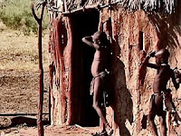
Traditionally, women tend to handle more labor-intensive work than the men do.  They carry water to the village, build the huts and care for the children. Men are responsible for maintaining relationships between clans and for tribal politics.  Both men and women go topless and wear skirts or loincloths made of animal skins, but most famously, the women are known for covering themselves with otjize, a mixture of butterfat and ochre that gives their skins a reddish-orange tinge.


Our Adventure started with a drive north to the town of Opuwo, Namibia.  Once there, and after several hours of searching, we meet the guide who would make our introductions to a Himba clan.   At his request, we bought a large sack of rice to give the clan as a gift, then left town in our overland truck in the direction of the Angolan border.

It was a hot dusty drive along some very rough roads, but eventually we approached a collection of huts and shelters sitting unprotected in the afternoon sun.  We had to wait in the truck while the driver and guide made their introductions and presented the sack of rice, but once they concluded the formalities, the clan allowed us to move freely around the village.

An impromptu Himba market

During the day, the adult men are with their animals, so only women and children were in the village.  They gathered under one of the few trees in the area and began laying out handmade trinkets in hopes of making a sale.  I made friends with a few of the boys by photographing them with my video camera and playing it back for them to watch.  In the meantime, Denise was making friends by allowing the children to fix her hair.  She ended up with ochre handprints all over the back of her shirt.

We remained with the clan for a few hours, but eventually returned to the truck, parched and in need of water.  Luckily, our overland truck carries a few hundred liters, but when the women saw us filling bottles from the water tap, they decided they could save themselves the daily walk to the river.  They came with their buckets and only said goodbye when they had drained the last of the water in the tank.  It was another great experience and a true adventure in traveling.